Residents’ water study
The Village wells and the aquifer
The Village of Wappingers Falls drinks from one place: a wellfield beside Wappinger Lake, fed by a shallow sand and gravel aquifer. The Ridge would clear and pave a wooded hillside in the area that drains toward it.
6,103
people served by the Village system (1,540 connections)
1 source
the Village wellfield on Canale Way, beside Wappinger Lake
≈1,260 ft
from the wells to the nearest edge of The Ridge site (approx.)
Elevated
State rating of the wells’ susceptibility to contamination
Where the area’s water comes from
Public water here comes from two kinds of source. The City and Town of Poughkeepsie, Hyde Park and Staatsburg drink treated Hudson River water (about 82,000 people). The Village of Wappingers Falls and the Town of Wappinger’s United Wappinger district drink from wells (about 19,500 people), which depend on what soaks into the ground around them. Homes outside these areas mostly have their own wells.
| Water system | Source | People served | Notes |
|---|---|---|---|
| Town of Poughkeepsie (townwide district) NY1302812 | Hudson River Hudson River, from the same joint plant | 43,000 | The Town uses about 4.5 million gallons a day and may take up to 10 by agreement. It is bringing three emergency wells near Wappinger Creek (Overlook Road) back online. |
| City of Poughkeepsie NY1330291 | Hudson River Hudson River, treated at the Poughkeepsies’ Water Treatment Facility (owned jointly by the City and Town) | 30,639 | |
| United Wappinger (Town of Wappinger) NY1330660 | Wells Atlas, Hilltop and Meadowwood wellfields | 14,000 | The Town’s source protection plan treats all three as groundwater under the direct influence of surface water, and cites studies estimating up to half of the Atlas and Hilltop yield comes from the neighbouring creeks. |
| Hyde Park Regional NY1302796 | Hudson River Hudson River, its own intake and treatment plant | 6,928 | Also supplies the Staatsburgh, Zone D & L and Pinebrook systems. Averaged about 1.1 million gallons a day in 2024. |
| Village of Wappingers Falls NY1302783 | Wells The Village wellfield beside Wappinger Lake (sand and gravel aquifer) | 5,522 | The Village’s only source; see the aquifer section below. |
| Staatsburg NY1302777 · boundary estimated by EPA | Hudson River Hudson River, bought from the Hyde Park system | 1,164 | |
| Greenfield (Hyde Park) NY1302794 · boundary estimated by EPA | Source not checked Not checked | 1,050 | |
| LaGrange Town Center NY1330320 · boundary estimated by EPA | Source not checked Not checked | 980 | |
| Fleetwood Manor (Town of Wappinger) NY1302779 · boundary estimated by EPA | Source not checked Not checked | 564 |
Service areas: state-supplied boundaries for the large systems and EPA estimates for small ones (dashed on the map), from the EPA’s Community Water System Service Area Boundaries. The Town of LaGrange’s Manchester district (two wells on Whites Bridge Lane, about 3,978 people) has no published boundary and is not drawn. Well locations are shown only roughly.
Where the Village’s water comes from
- All Village water comes from wells at the 8-acre Village wellfield on Canale Way, on the shore of Wappinger Lake. In 2025 the treatment plant supplied about 494,000 gallons a day to about 6,103 people.
- Of the three active wells, Well #3 stayed offline through 2025 because of manganese, so the Village ran on two wells (#7 and #7A). The Village’s plan says it is looking for a backup source because it depends on this single wellfield.
- The wells draw from a sand and gravel aquifer. The State’s source water assessment rates the wellfield as having “an elevated susceptibility to microbial and nitrate contamination”, due mainly to residential land use and related activity in the area, and notes that the soils above the aquifer “may not provide adequate protection.”
- In 1993 the County’s Water and Wastewater Authority placed Wappinger Lake in a Zone 1 Aquifer Protection Area, where, in the Village plan’s words, contaminants can move down to the aquifer “with little or no natural filtration by the soil.” In 1998 the Village made the lake and the wellfield a Critical Environmental Area.
Where The Ridge sits
A Source Water Protection Plan prepared for the Village by the New York Rural Water Association (2016) mapped three zones around the wells: Zone 1 immediately around them, Zone 2 (the “zone of contribution” whose groundwater reaches the wells) and Zone 3 (the tributary watershed that drains into it). On that map, The Ridge site falls mostly within Zone 3, with its eastern side running along Zone 2, uphill of the wells.
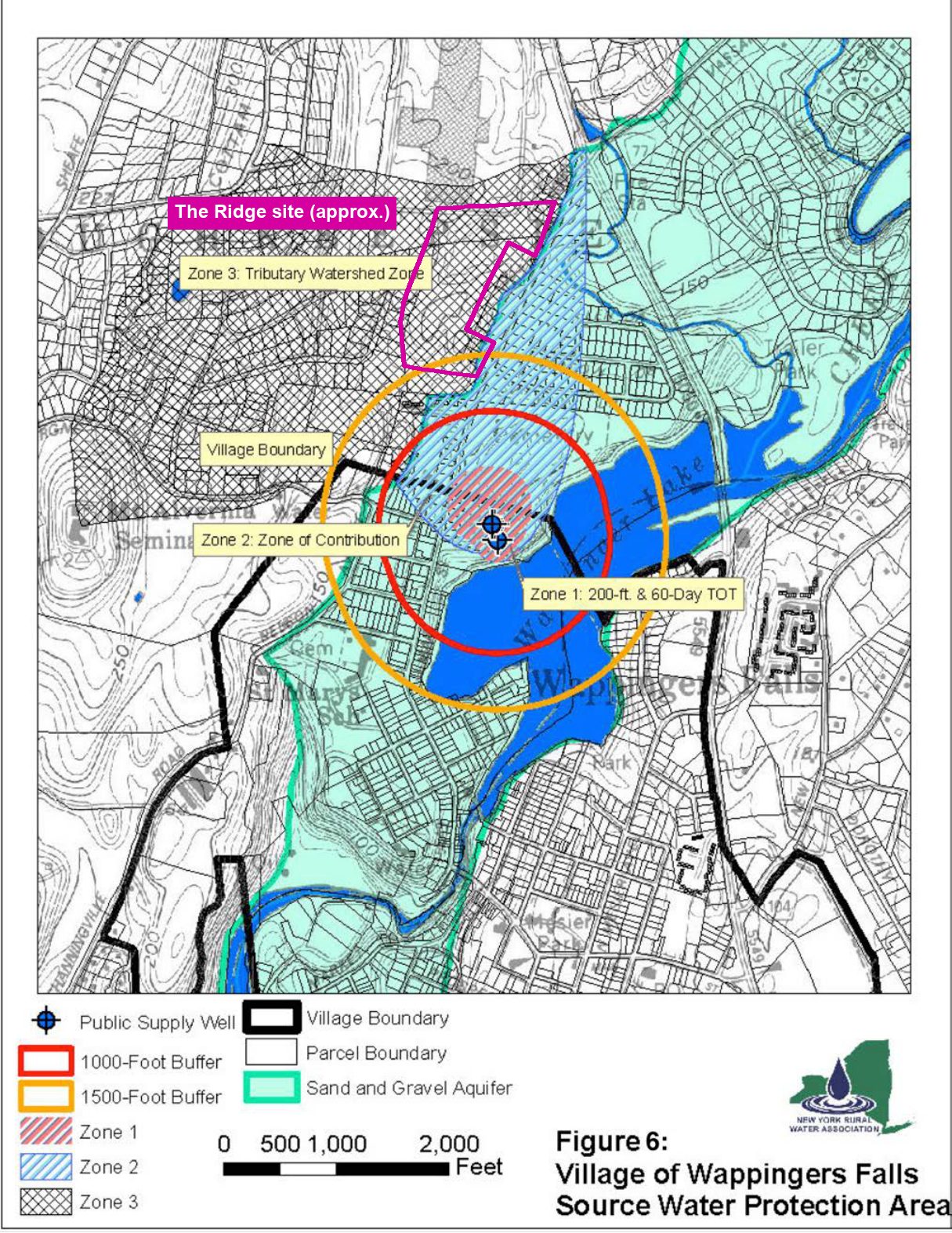
The Village’s Comprehensive Plan asks the Village to “inform the Town of Poughkeepsie of the Village’s source water protection area and ask that they consider potential impacts on the water supply when making decisions to approve projects within this critical area.” The Ridge is such a project.
What the development would change
- 23 wooded acres cleared on a hillside with slopes over 25%. Woods and forest soil soak up and filter rain before it reaches groundwater.
- Roofs, roads and about 246 parking spaces in their place, with runoff sent to infiltration and bioretention basins, which put stormwater into the ground in the area that drains toward the wells.
- Winter road salt on the new roads and parking lots. The Village’s 2025 tests found chloride at 106 mg/L (the limit is 250), with road salt among the listed sources. Sodium was 161 mg/L; the Village’s softening plant also adds sodium, so the tests can’t say how much comes from salt. New York advises that water with more than 20 mg/L of sodium should not be used for drinking by people on severely restricted sodium diets.
- Construction: months of excavation, fuel and equipment on the slope above the aquifer.
Questions for the Town Board
- Has the applicant mapped the site against the Village’s Source Water Protection Plan zones?
- Has the Village of Wappingers Falls, and its Board of Water Commissioners, been notified and consulted, as the Village has asked?
- How would stormwater be treated before it is infiltrated in the area draining to the Village wells?
- What salt management would apply to the new roads and about 246 parking spaces?
- What protections would apply during construction on the slope?
Sources
- Village of Wappingers Falls, Annual Drinking Water Quality Report for 2025 (wells, people served, source water assessment, test results).
- Village of Wappingers Falls, Comprehensive Plan (2023), Part 1: chapter 3, Village Water Supply, and Figures 5 and 6.
- Water sources and service: Poughkeepsies’ Water Treatment Facility, 2025 water quality report; Hyde Park Regional, 2024 report; Town of Wappinger drinking water source protection plan; Town of LaGrange Manchester water report (2023); Town of Poughkeepsie Comprehensive Plan, Utilities.
- The Ridge site: Dutchess County tax parcel 6158-01-290785; site figures from the applicant’s concept plan (Town Board packet, September 23, 2026).
- Compiled by residents from public documents; it may contain errors. The site overlay is approximate.